English French German Spain Italian Dutch Russian Portuguese Japanese Korean Arabic Chinese Simplified

Canyoning Paullo II

Posted: by EFREN LOPEZ in Labels:
0


The first three weekends of July, Two members of our team, (Efren Lopez and Ronald Miranda.) explored the lower part of Paullo canyon. First we decided to explore the upper right side of canyon and check possible access, anchorage points for abseils, gaps, escapes and the route´s exit, then we got into the canyon.

The lower part begins at 3100mtrs and ends at 3000mtrs, it means a slope of 100mtrs approximately until bottom of the canyon that involve challenging rapelings, cut in sandstone with some deep sections, it has an average difficulty with a moderate water flow, several abseils, small pools, water slides, small edges, rock hoping. Undoubtedly one of the best canyoning experiences in the region. Located into the heart of the Sacred Valley of the Incas.

to reach the canyoning from village the access takes about 40 min going up by the left side of the canyon. located over 3100 mtrs, there is the first access, the canyoning. the route start with a 10 mtrs abseil until the to the top of the first waterfall of 20 mtr, them after a very deep slot, the route continue for 12mtrs downclimbing  followed by a cascade of 8 mtrs with a small pool, a little further on the right side is the first escape of the canyon, the route continues for another small waterfall 10 mtrs, there exists another escape to the rightside, the last part is a 30 mtrs abseil through a series of waterfalls, route ends on a small pool after a cave. the route has mostly natural anchors for abseil along the way down such as rocks and trees.

It is important to mention for participate in a canyoning expedition a fundamental requirement is to take the proper equipment for this activity ie.. ropes, safety lines, helmets, harnesses, wetsuits, dry bags, adequate shoes etc
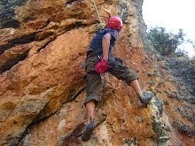
The abseil skills and rope work are definitely required, during a canyoning expedition, overcome OBSTACLES while descending a rope in a very, wet and slippery environment is common issue.
The water temperature into the canyon range between 15ºc to 19ºc, the use of thermic suit is mandatory requirement to avoid hypothermia.
The geography of the gorge and the water volume may change during the rainy season , (it last from December to April), which increases the difficulty level and change canyoning access, abseils, escapes and exit, it is always advisable to make the trip with guides who know the terrain and its features.

For further info contact us: elefrenlp64@gmail.com

Veronica Mountain Ice Climbing

Posted: by EFREN LOPEZ in Labels: ,
0

Veronica mountain Apu wacaywillca is located  north west of Cusco city, is the highest mountain into Urbamba range, its summit reach 5911m/19393 ft located at coordinates 13 ° 9'52 .49 "S 72 ° 19'34 .11" O, considered a tropical mountain because is located in the northwest corner of Urubamba mountain range, a natural border that divides the Andean region of the jungle.

The last week of May I participated of a mountaineering expedition to reach the summit of Veronica mountain, by the south east route. thanks to Nate Heald invitation  and Sky High Expeditions. Among objectives of expedition were to reach mountain summit with the first woman and the first Brazilian mountaineer, expedition was planned for 4 days with 8 people including experienced mountaineers and guides.

The first day expedition early in the morning we headed north to Malaga pass over 4300 m, once there we got ready and the team began the approach walking west about 4 hrs to base camp over 4600 mtrs there we set camp and took the rest of the day to acclimatize and rest.

The Second day in the morning we continued towards the advanced camp over 4900 m 1 hour walk, but when we reached it and set tents, 4 people of the expedition did not feel good because altitude so they decided to return to base camp. e continued, it took a couple of hours more to set a rope at the start of the route then we returned to the advanced camp.
 with only 4 of us, we decided to continue.  Nate leaders of expedition, Waldemar a renowned Brazilian mountaineer, me and Macario. we sleep the rest of the night and left the advanced camp at 12 30 pm in total darkness. Definitely this is a technical mountain so we climbed to alpine style because the speed and the time it takes to reach the top and return.
Third day at dawn climbing continued by a mixed part (rock and ice) of approx 40 ms then a long gutter of 50 degree tilt and 300 m  direct to south ridge, about 5 am,  on the the ridge the sun rose, the average slope of walls varies between about 65 and 75 degrees with some technical steps on crevasses covered with soft snow in the last 3 hours of climbing.

May 29, 2014 at 8 30 am, after 8 hours climbing we reached the top of the Veronica mountain Apu Wacaywilca the highest mountain of Urubamba range, an spectacular scenery of the mountain ranges that surround this peak as Vilcanota Urumanba and vilcabamba ranges, an amazing landscape. After rest 1 hour on the summit we went back descending by same ridge with  loose snow due to sun, which exposed the crevasses a little more then we unclimbed the 300 m gutter and rappel the mix part we return to advanced camp about 3 30 pm and decided to descend to base camp on the same day.

the fourth day after breakfast our team got ready and walked about 3 hours return to Tastayoc for take the  transportation back to Cusco.
Important to note that the best months to climb Veronica mountain are May, June and July because snow conditions and the appearance of crevasses in the route, Definitely a challenge this is not a mountain for beginners because it involves a high degree of technical skills in mountaineering, good physical condition, acclimatization.


For further info contact us: elefrenlp64@gmail.com

Apu Pachatusan Mountain Scrambling

Posted: by EFREN LOPEZ in Labels: ,
0

The Pachatusan mountain has a special meaning within the Andean culture, considered an Apu or sacred mountain venerated in the region of Cusco, where people held up ceremonies, rituals and offerings since Inka`s Time until these days, this mountain is located 30 km east of the city of Cusco, and its summit reaches 4700 meters. but The mountain has 3 different summits of similar altitude formed by sandstone, the weekend we organized a scrambling to this mountain, it took us two days.

the first day by morning we left Cusco, The Scrambling route begins in the village of Huasao located over 3130 mts at 30 km east of the city. the climb goes by the north face of the mountain and it has a distance of 10 km from Huasao village to the main summit, mostly all way up, through a semi desert area covered by Andean grass, and sandstone outcrops, the village of kacllapata is located halfway, the first day we camp before sunset near the top of mountain
the second day by morning we continued and reached the summit of Pachatusan mountain over 4700 mtrs at 11 am after half an hour to enjoy spectacular scenery, we decided to return, this time all way down straight to Huasao village, we arrived there at sunset.
there is also an Inca road that goes from Huasao to the top of the mountain the road is very noticeable wide in some parts of the route.

This is a relatively easy scrambling it does not requires climbing equipment but you need a good physical condition to climb the 1570 mtrs of altitude and a distance of 20 km round trip preferably during 2 days.

This Scrambling is recommended during the dry season be carefull during the rainy season because there is danger of heavy rain,  fog, unexpected snowfall and lightning.


For further info contact us: elefrenlp64@gmail.com